Episode Themes & Story Ideas
Tags: vault
Related:
unorganized story themes:
- designated driver
- dumpster diving
- middle of nowhere
- backpacking shelters
- caught on camera
- Found footage
- emergency
- college
- the queen mary
- voodoo
- 3am // middle of the night
- 911 calls
Categories (A-Z)
Note: If a word is linked below (ex: woods), it will lead you to that tag where you can find all other mentions of that topic
adventure & travel stories
- ATV trail
Backpacking & Hiking Stories :
Similar themes & tags:
- backpacking
- hiking
- campfire
- camping // solo camping ⬅️ included in “Mother Nature” section below // wild camping
- fishing ⬅️ included in “Mother Nature” section below
- hunting ⬅️ included in “Mother Nature” section below
- hiking ⬅️ included in “Mother Nature” section below
- National Park Stories
- shelters in the woods
- Fire Lookout
- hostel
- solo traveling
- spelunking (a.k.a. caving)
Mass & Public Transit Stories :
On The Road Stories :
Similar themes & tags:
- driving @ night
- gas station
- 7-eleven
- GPS disaster stories
- highway/interstate stories
- on the road // roadtrip
- van life
- Wrong Turn
- urban exploration // Urbex Stories
- what’s the scariest city you’ve ever been to? (inspired by this Reddit thread)
childhood stories (main tag: childhood)
- at school:
- elementary school
- 5th grade
- high school
- elementary school
- birthday party
- childhood trauma
- Dark Family Secrets
- imaginary friends
- most unsettling things children have said
- sleepovers
confession stories
- Psycho Ex Stories
- what’s the most fucked up thing someone confessed to you in confidence?
creepy stories (main tag: creepy)
- creepy thrift store finds
- cults
- Inspired by this Reddit thread’s “Cult” subheading:
- Ex-cult members, what’s your “Oh shit, I’m in a cult” moment?
- Do you know anyone who fell victim to a cult? What happened?
- People who study cults, what usually happens when their leader dies?
- Former cult members – what was the exact moment you realized you were in a cult?
- What is the most creepy cult you know about?
- Inspired by this Reddit thread’s “Cult” subheading:
crime stories (main tag: crime)
- blackmail
- kidnap
- lockdown
- robbery
Fears & Phobias
- clowns
holiday stories
- Christmas
- 4th of july
- Halloween
- Holiday break-ins
house horrors (cue “House” song by Ethel Cain)
- home alone ( KEVIN )
- house fires / floods
- home invasion
- Landlord disasters
- Maintenance repair horror stories
- New house Stories
- Nightmare tenants
- stalking neighbor
- phrogging
- video games
- xbox
- vhs // home movies
international stories (A-Z) (main tag: international)
lore & legends (main tag: lore & legends)
- urban legends
- Inspired by this Reddit thread’s title: What’s an urban legend you know that’s actually true?
mother nature & the great outdoors
- campfire
- camping
- fishing
- forest // national forest // state forest
- hunting
- hiking
- Natural Disaster Stories
- off-grid
- Refusing to evacuate during a hurricane / forest/wild fire
- Storm chasing close calls / disasters
- water-related // water story vault
online & dark web
- 4chan
- Facebook live
- hackers
- internet rabbit hole
- deepest internet rabbit hole you’ve ever fallen into
- Reddit
- Anon Reddit Confessions // dark confessions story vault
- scammers
- CarlHProgramming – “CarlHProgramming. The guy helped people with their programming with tutorials and had his own subreddit. He turned out to be a pedophile who raped and molested his own son. After getting arrested he hung himself in prison. I really hope that poor kid is doing okay.”
paranoia
- intuition / instinct
- Inspired by this Reddit thread’s title: When did your instincts scream “leave now” and what did you later find out you avoided?
- Inspired by this Reddit thread’s title: What is the single most intense “This is NOT a drill” moment you experienced while abroad that you had to rely on pure instinct to survive or escape?
- stalker / surveillance
paranormal & the unexplained
- 9/11 ghost stories
- cryptids
- skinwalkers
- wendigo
- demons
- ghosts
Glitch in the matrix stories :
Similar themes & tags:
- glitch in the matrix
- mimics / doppelgängers
- near death experiences (NDEs) story vault
- UFOs // ufo – UFO story vault
- uncanny valley
- unexplained
- unsolved mysteries
- urban legends
state & geographic-themed stories
Considered Appalachia:
Tags: Appalachia
Related Booze & Boos Episode(s):
Wikipedia: Appalachia
NOTE: U.S. portion is considered the Appalachian Highlands and the Canadian portion is considered the Appalachian Uplands
Created/Accessed:
02-17-2026 14:37
Status: Adding & tagging counties as I find interesting stories for the vault!
Important Location(s):
Appalachian States (ARC Defined Region):
- Alabama: 37 counties in the northern part of the state.
- Georgia: 37 counties in the northern part of the state.
- Kentucky: 54 eastern and southern counties.
- Maryland: Allegany, Garrett, and Washington counties.
- Mississippi: 24 northeastern counties.
- New York: 14 counties, including areas around the Southern Tier.
- North Carolina: 29 western counties.
- Ohio: 32 southern and eastern counties.
- Pennsylvania: 52 counties, covering most of the state except for the southeast and northwest corners.
- South Carolina: 6 northwestern counties.
- Tennessee: 52 eastern and middle counties.
- Virginia: 25 counties and 8 independent cities in the southwestern part of the state.
- West Virginia: All 55 counties are within the region.
Notes & Quotes from Sources:
Counties in Appalachia
- NOT considered Appalachia don't tag bc it’s not relevant
Alabama (37 counties): Bibb, Blount, Calhoun, Chambers, Cherokee, Chilton, Clay, Cleburne, Colbert, Coosa, Cullman, De Kalb, Elmore, Etowah, Fayette, Franklin, Hale, Jackson, Jefferson, Lamar, Lauderdale, Lawrence, Limestone, Macon, Madison, Marion, Marshall, Morgan, Pickens, Randolph, St. Clair, Shelby, Talladega, Tallapoosa, Tuscaloosa, Walker, and Winston
Georgia (37 counties): Banks, Barrow, Bartow, Carroll, Catoosa, Chattooga, Cherokee, Dade, Dawson, Douglas, Elbert, Fannin, Floyd, Forsyth, Franklin, Gilmer, Gordon, Gwinnett, Habersham, Hall, Haralson, Hart, Heard, Jackson, Lumpkin, Madison, Murray, Paulding, Pickens, Polk, Rabun, Stephens, Towns, Union, Walker, White, and Whitfield
Kentucky (54 counties): Adair, Bath, Bell, Boyd, Breathitt, Carter, Casey, Clark, Clay, Clinton, Cumberland, Edmonson, Elliott, Estill, Fleming, Floyd, Garrard, Green, Greenup, Harlan, Hart, Jackson, Johnson, Knott, Knox, Laurel, Lawrence, Lee, Leslie, Letcher, Lewis, Lincoln, McCreary, Madison, Magoffin, Martin, Menifee, Metcalfe, Monroe, Montgomery, Morgan, Nicholas, Owsley, Perry, Pike, Powell, Pulaski, Robertson, Rockcastle, Rowan, Russell, Wayne, Whitley, and Wolfe
Maryland (3 counties): Allegany, Garrett, and Washington
Mississippi (24 counties): Alcorn, Benton, Calhoun, Chickasaw, Choctaw, Clay, Itawamba, Kemper, Lee, Lowndes, Marshall, Monroe, Montgomery, Noxubee, Oktibbeha, Panola, Pontotoc, Prentiss, Tippah, Tishomingo, Union, Webster, Winston, and Yalobusha
New York (14 counties): Allegany, Broome, Cattaraugus, Chautauqua, Chemung, Chenango, Cortland, Delaware, Otsego, Schoharie*, Schuyler, Steuben, Tioga, and Tompkins
- Schoharie County is covered by two regional commissions but may only receive assistance from one commission in a given fiscal year. Schoharie County has elected not to be eligible for ARC assistance in FY 2026. If your proposed project includes Schoharie County, please coordinate with New York’s State Program Manager to discuss this matter further.
North Carolina (31 counties): Alexander, Alleghany, Ashe, Avery, Buncombe, Burke, Caldwell, Catawba, Cherokee, Clay, Cleveland, Davie, Forsyth, Graham, Haywood, Henderson, Jackson, McDowell, Macon, Madison, Mitchell, Polk, Rutherford, Stokes, Surry, Swain, Transylvania, Watauga, Wilkes, Yadkin, and Yancey
Ohio (32 counties): Adams, Ashtabula, Athens, Belmont, Brown, Carroll, Clermont, Columbiana, Coshocton, Gallia, Guernsey, Harrison, Highland, Hocking, Holmes, Jackson, Jefferson, Lawrence, Mahoning, Meigs, Monroe, Morgan, Muskingum, Noble, Perry, Pike, Ross, Scioto, Trumbull, Tuscarawas, Vinton, and Washington
Pennsylvania (52 counties): Allegheny, Armstrong, Beaver, Bedford, Blair, Bradford, Butler, Cambria, Cameron, Carbon, Centre, Clarion, Clearfield, Clinton, Columbia, Crawford, Elk, Erie, Fayette, Forest, Fulton, Greene, Huntingdon, Indiana, Jefferson, Juniata, Lackawanna, Lawrence, Luzerne, Lycoming, McKean, Mercer, Mifflin, Monroe, Montour, Northumberland, Perry, Pike, Potter, Schuylkill, Snyder, Somerset, Sullivan, Susquehanna, Tioga, Union, Venango, Warren, Washington, Wayne, Westmoreland, and Wyoming
South Carolina (7 counties): Anderson, Cherokee, Greenville, Oconee, Pickens, Spartanburg, and Union
Tennessee (52 counties): Anderson, Bledsoe, Blount, Bradley, Campbell, Cannon, Carter, Claiborne, Clay, Cocke, Coffee, Cumberland, De Kalb, Fentress, Franklin, Grainger, Greene, Grundy, Hamblen, Hamilton, Hancock, Hawkins, Jackson, Jefferson, Johnson, Knox, Lawrence, Lewis, Loudon, McMinn, Macon, Marion, Meigs, Monroe, Morgan, Overton, Pickett, Polk, Putnam, Rhea, Roane, Scott, Sequatchie, Sevier, Smith, Sullivan, Unicoi, Union, Van Buren, Warren, Washington, and White
Virginia (25 counties): Alleghany, Bath, Bland, Botetourt, Buchanan, Carroll, Craig, Dickenson, Floyd, Giles, Grayson, Henry, Highland, Lee, Montgomery, Patrick, Pulaski, Rockbridge, Russell, Scott, Smyth, Tazewell, Washington, Wise, and Wythe
The following independent cities in Virginia are also within the Appalachian Region and are merged with an adjacent or surrounding county for the purposes of data analysis and grant management: Bristol (Washington County), Buena Vista (Rockbridge County), Covington (Alleghany County), Galax (Carroll County), Lexington (Rockbridge County), Martinsville (Henry County), Norton (Wise County), and Radford (Montgomery County).
West Virginia (55 counties): Barbour, Berkeley, Boone, Braxton, Brooke, Cabell, Calhoun, Clay, Doddridge, Fayette, Gilmer, Grant, Greenbrier, Hampshire, Hancock, Hardy, Harrison, Jackson, Jefferson, Kanawha, Lewis, Lincoln, Logan, Marion, Marshall, Mason, McDowell, Mercer, Mineral, Mingo, Monongalia, Monroe, Morgan, Nicholas, Ohio, Pendleton, Pleasants, Pocahontas, Preston, Putnam, Raleigh, Randolph, Ritchie, Roane, Summers, Taylor, Tucker, Tyler, Upshur, Wayne, Webster, Wetzel, Wirt, Wood, and Wyoming
Canadian Appalachian Uplands
The Appalachian Uplands is one of the seven physiographic regions in Canada, 1distinguished by its topography and geology. The region includes southern Quebec, Gaspésie, New Brunswick, Nova Scotia, Prince Edward Island and the island of Newfoundland. 1 This is the Canadian portion of the Appalachian Mountains. The United States equivalent portion is called the Appalachian Highlands.
Physiographic regions, subregions, and divisions
edit
The Geological Survey of Canada uses three levels of physiographic classification. The "region" is the highest level, which is equivalent to the "division" level in the United States. In the Appalachian Uplands, there is no second-level, which in Canada is the "subregion." There are 13 tertiary-level areas (called divisions in Canada) in the Appalachian Uplands region. 1

Notre-Dame Range, hills belonging to the Appalachian Mountains, Quebec, Canada
- Newfoundland contains the Newfoundland Highlands, Atlantic Uplands, and Central Lowlands
- Nova Scotia contains the Atlantic Uplands, Nova Scotia Uplands, and the Annapolis Lowlands
- New Brunswick contains the New Brunswick Highlands, the Chaleur Uplands, and the Maritime Plain
- Quebec contains the Notre-Dame Mountains, Eastern Quebec Uplands, Sutton Mountains, and Mégantic Hills
Features include Gros Morne National Park and the Newfoundland Highlands in Newfoundland, the Cobequid Mountains, Antigonish Highlands, Cape Breton Highlands, Nova Scotia Uplands, and the Annapolis Lowlands in Nova Scotia, the New Brunswick Highlands, Notre-Dame Mountains including the Chic-Chocs Mountains, Sutton Mountains, and Mégantic Hills in Quebec, and the Maritime Plain, "which stretches around the coast of New Brunswick and Nova Scotia from the south shore of Chaleur Bay and includes Prince Edward Island and Îles-de-la-Madeleine." 1
Appalachian Uplands
The Appalachian Uplands extends from southern Quebec and Gaspésie to encompass New Brunswick, Nova Scotia, Prince Edward Island and the island of Newfoundland.
On the island of Newfoundland, the Appalachian Uplands comprises three highlands that form a group called the Newfoundland Highlands. They are rugged with steep slopes and elevations vary from 180 to 820 metres. On the east side, the Atlantic Uplands of Newfoundland lie between 180 and 300 metres in elevation, and the Newfoundland Central Lowland extends from sea level up to 150 metres. Its surface is gently rolling and generally underlain by glacial sediments.
Nova Scotia is divided into three highland areas, three uplands and several small lowlands. The Nova Scotia Highlands include the Cobequid Mountains in the west, the Antigonish Highlands in the centre and the Cape Breton Highlands to the northeast. South of these highlands lay the Nova Scotia Uplands and the Annapolis Lowlands.
New Brunswick comprises three large units: the New Brunswick Highlands; the Chaleur Uplands, which cross the Quebec–New Brunswick border; and the Maritime Plain, which stretches around the coast of New Brunswick and Nova Scotia from the south shore of Chaleur Bay and includes Prince Edward Island and Îles-de-la-Madeleine.
In Quebec, the Chaleur Uplands are bounded on the north by the Notre-Dame Mountains, which extend from near Thetford Mines to Baie de Gaspé. In the Notre-Dame Mountains area, there are the Chic-Chocs Mountains which have the highest elevation at more than 1230 metres in the north. To the southwest, the summits are lower, like the areas of Mégantic Hills and Sutton Mountains, which merge with the Eastern Quebec Uplands. The Sutton Mountains are a continuation of the Green Mountains of Vermont; and the Mégantic Hills lie astride the Canada–United States boundary and are part of the larger White Mountains of the New England states.
The following photographs show examples of landscapes from the Appalachian Uplands.
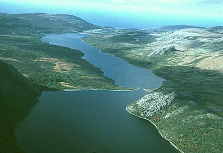
Figure 28: Gros Morne National Park, Newfoundland and Labrador. This photograph, taken in Gros Morne National Park on Newfoundland, shows a wide U-shaped valley 23 that was formed by erosion from repeated advances of glaciers from the Newfoundland ice sheet.
Source: Geological Survey of Canada, photograph number 2002-089. Reproduced with the permission of the Minister of Public Works and Government Services Canada, 2005 and courtesy of Natural Resources Canada, Geological Survey of Canada.
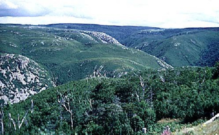
Figure 29: Cape Breton Island, Nova Scotia. This photograph, taken on Cape Breton Island in Nova Scotia, shows the flat and virtually unmodified surface of the highlands, which contrasts with the branching network of river gorges that incise its margins.
Source: Geological Survey of Canada, photograph number 120182. Reproduced with the permission of the Minister of Public Works and Government Services Canada, 2005 and courtesy of Natural Resources Canada, Geological Survey of Canada.
These states are Appalachian (although not each COUNTY is in the ARC Defined Region, so be sure to confirm specifics using the document above ^)
- Alabama Stories
- Georgia Stories
- Kentucky Stories
- Maryland Stories
- Mississippi Stories
- New York Stories
- North Carolina Stories
- Ohio Stories
- Pennsylvania Stories
- South Carolina Stories
- Tennessee Stories
- Virginia Stories
- West Virginia Stories
-
Checking off the states that have been organized by region!
-
If a page is grayed out/inactive, that means I don’t have content for those states yet (i.e., they are currently just placeholders) – I will publish pages as I expand our database :)
A-Z
- Alabama – The South // Appalachia
- Alaska – The Pacific West
- Arizona – The Mountain West
- Arkansas – The South // South Central
- California – The Pacific West
- Colorado – The Mountain West
- Connecticut – New England
- Delaware – Mid-Atlantic
- Florida – The South
- Georgia – The South // Appalachia
- Hawaii
- Idaho – The Mountain West
- Illinois – The Midwest
- Indiana – The Midwest
- Iowa – The Midwest
- Kansas – The Midwest
- Kentucky – The South // Appalachia
- Louisiana
- Maine – New England
- Maryland – Mid-Atlantic // Appalachia
- Massachusetts – New England
- Michigan – The Midwest
- Minnesota – The Midwest
- Mississippi – The South // Appalachia
- Missouri – The Midwest
- Montana – The Mountain West
- Nebraska – The Midwest
- Nevada – The Mountain West
- New Hampshire – New England
- New Jersey – Mid-Atlantic
- New Mexico – The Mountain West
- New York – Mid-Atlantic // Appalachia
- North Carolina – The South // Appalachia
- North Dakota – The Midwest
- Ohio – The Midwest // Appalachia
- Oklahoma
- Oregon – The Pacific West
- Pennsylvania – Mid-Atlantic // Appalachia
- Rhode Island – New England
- South Carolina – The South // Appalachia
- South Dakota – The Midwest
- Tennessee – The South // Appalachia
- Texas
- Utah – The Mountain West
- Vermont – New England
- Virginia – The South // Mid-Atlantic // Appalachia
- Washington – The Pacific West
- West Virginia – The South // Mid-Atlantic // Appalachia
- Wisconsin – The Midwest
- Wyoming – The Mountain West
New England:
Mid-Atlantic:
Maryland Stories:
The South:
Alabama Stories:
Florida Stories:
Kentucky Stories :
- Mississippi Stories
- North Carolina Stories
- South Carolina Stories
- Tennessee Stories
- Virginia Stories
- West Virginia Stories
The Midwest:
Kansas Stories :
- Kansas Stories
Michigan Stories :
- Minnesota Stories
- Missouri Stories
- Nebraska Stories
- North Dakota Stories
- Ohio Stories
South Dakota Stories :
Wisconsin Stories :
The Mountain West:
Idaho Stories :
Montana Stories :
- Nevada Stories
- New Mexico Stories
- Utah Stories
- Wyoming Storoes
The Pacific West:
Alaska Stories :
- California Stories
- Oregon Stories
- Washington (State) Stories
All Other States:
Maine Stories :
Subcategories:
- small town/rural stories
summertime stories
- summer camp / wilderness camp
- Theme parks
- six flags
throwback stories
work stories (main tag: work stories)
- Bounty Hunter Stories
- Delivery Driver Stories
Night Shift Stories :
- Offshore Oil Rig Stories
- park ranger
- Private Investigators
- Tow Truck Driver Stories
Medical Stories :
- unsettling hospital stories
- scariest thing a patient has ever done or said (inspired by this Reddit thread)
Military Stories :
Police/911/Dispatch Stories :
Train engineers :
AskReddit post